Flood prevention and control work in small and medium-sized rivers is an important part of protecting people's lives and property, protecting the ecological environment, and promoting sustainable social development. Especially during the flood season, due to factors such as heavy rains and climate change, river water levels may change rapidly, which can easily cause flood disasters. The flood prevention and control water level monitoring system is like a loyal guard, standing guard around the clock to prevent floods from escaping.

1. System composition and principle
The natural river flow monitoring system has front-end equipment such as flow radar flowmeter, radar water level sensor, radar velocity meter, data collector, communication module (wired or wireless), power supply system and monitoring platform including software and hardware equipment for receiving, storing, analyzing and displaying monitoring data. Users can access the monitoring platform through terminal devices such as computers and mobile phones to understand the flow of the river in real time. It aims to record and analyze the flow information of the river water body in real time.
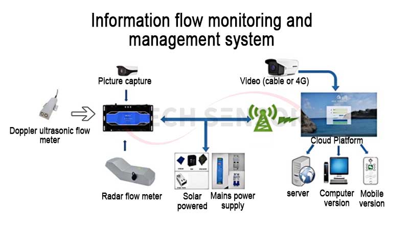
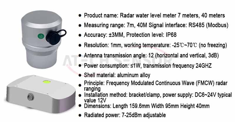
Radar water level meter: used to measure the water level of a river. By transmitting radar waves and receiving reflected waves, the distance from the water surface to the sensor is calculated to obtain the water level value. Wide measurement range, high accuracy, non-contact measurement
Telemetry terminal: responsible for reading and summarizing data from various sensors and performing preliminary processing, with strong data processing capabilities and stable transmission performance. Supports flow rate and water level conversion flow
Radar flowmeter: used to measure the flow velocity on the surface of water flow. It emits electromagnetic waves to the water surface and calculates the speed of the water flow based on the Doppler frequency shift of the reflected electromagnetic waves. It can accurately reflect the changes in water flow velocity in real time
Radar flowmeter is a radar-type flow measurement product that can simultaneously measure water level, flow velocity, flow rate, and cumulative flow rate. It uses the Doppler radar velocity measurement principle to detect the surface flow velocity of the water flow, and the built-in radar water level meter can be used to measure the water depth. By measuring the water depth and flow velocity and the cross-sectional shape set inside the device, the velocity area method can be used to calculate the flow velocity of the cross section. Microwave radar is not affected by temperature gradients, pressure, air density, wind or other meteorological environmental conditions, and is easy to maintain and use.

2. High-precision water level sensor features outstanding performance
1) Accurate measurement and real-time transmission: The water level measurement accuracy can reach centimeters or even higher standards. Whether it is a slow rise in water level or a sharp flood peak, it can be accurately recorded. Data transmission has almost zero delay, allowing the monitoring center to grasp the dynamics of the river water level in the first time and gain valuable time for decision-making.
2) Multi-site coordination and seamless coverage: Multiple sites can be deployed along small and medium-sized rivers to form a dense monitoring network to achieve seamless coverage of the entire river or key areas.
3) Intelligent early warning and graded response: The system has built-in intelligent algorithms, which automatically issue different levels of early warning information based on the preset water level warning threshold. If the water level approaches the warning level, an early warning will be issued to remind relevant departments to pay close attention;
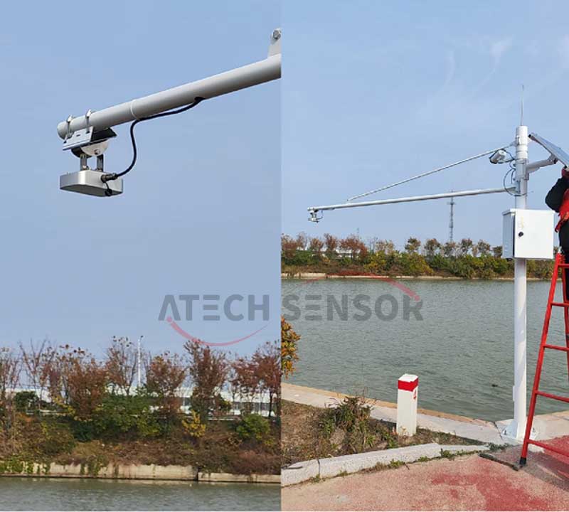
4) Adapt to complex environments and stable operation: Whether it is high temperature, severe cold and freezing, or severe weather such as heavy rain, wind, sand, dust and haze, the system can operate stably. Waterproof, moisture-proof, lightning protection and other protective designs make it safe in the wild river environment and continue to provide reliable water level monitoring data
3. Core advantages of the water level monitoring system for small and medium-sized rivers
1) All-weather operation
The system uses low-power equipment, supports long-term continuous operation, and can operate stably under extreme weather conditions (such as heavy rain, freezing, etc.). By designing waterproof, anti-corrosion, lightning protection and other protective measures, the long-term stability of the equipment is ensured.
2)No-dead-angle monitoring
Multi-point monitoring, combined with different types of sensors and auxiliary technologies (such as drones, remote sensing, etc.), can achieve comprehensive coverage and avoid blind spots and missed monitoring that may occur in traditional point monitoring.
3) Efficient early warning response
Through comprehensive analysis of intelligent analysis, meteorological data, and historical data, the system can provide accurate flood warnings, timely discover potential risks and issue early warning information, deploy flood control work in advance, and reduce losses.
4) Data visualization and remote control
The system provides rich data visualization functions, and managers can intuitively understand the water level of each monitoring point through charts, maps, etc. In addition, the system supports remote control, and personnel can command flood control measures through remote operation.

The flood control and water level monitoring system for small and medium-sized rivers can achieve all-weather and all-round monitoring of river water levels by integrating a variety of cutting-edge technologies. The system not only improves monitoring efficiency and avoids missed detections and blind spots, but also provides data support for flood control decisions through intelligent analysis and real-time warnings, significantly improving the emergency response capabilities of flood control and prevention, and ensuring the safety of people’s lives and property and social stability.